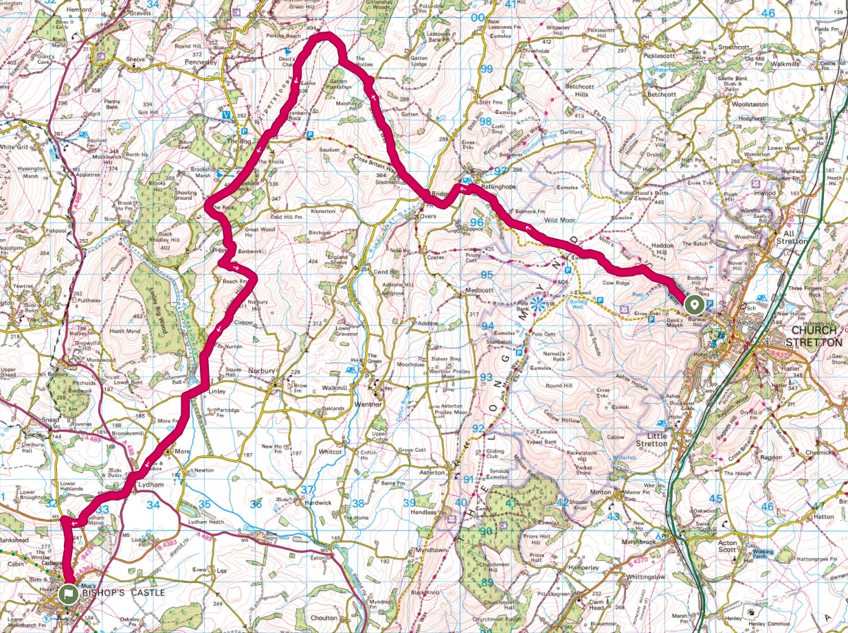
Bridges was my starting point for the days walk. Unfortunately, it is somewhat inconvenient to drive to, so in order not to upset the chauffeur I elected to be dropped at the Carding Mill National Trust car park in Church Stretton and would walk over.
Carding Mill to Bridges is a straightforward walk of around 4 1/2 miles but does have the Long Mynd in the way, the plateau of which, is some 500m above sea level, Carding Mill being around 200m above sea level, gave me quite a climb straight out of the car. Actually, it is a pleasant walk on a good path, which leads to the Light Spout waterfall. From there, around the side and the plateau is soon reached. Today, the views were pretty much non-existent due to the very low cloud, but on a clear day, it is wonderful and you might even be lucky enough to spot a glider or two from the nearby gliding club.

Onwards and downwards I eventually came to the woodland that leads into Bridges and was actually the end of the previous section. I was retracing familiar ground, walking into Bridges and passing the Youth Hostel, now just a 'hostel' and although it does still have the YHA triangle, it is, in fact, a privately run hostel.

Out of Bridges, there are a couple of kilometres of road walking, although it is on a small lane. Having said that, I was passed by several cars, presumably heading up to the car park for the Stiperstones, my next objective. The Way parts company from the direct route up and continues along an even smaller lane until breaking off onto a farm track, through the farm and out onto the Stiperstones nature reserve. Through a gate and up onto the very rocky ridge. There is a clear path, but it is very stony and requires a lot of care to avoid slips and trips. Passing the rocky outcrops I noticed a distinct drop in temperature and considered putting on an extra layer, but as is usual for me, I continued a little, hoping I would soon be sheltered. I was in luck, the path moved to the lee side and the wind vanished (for now).

Within a couple of minutes the summit trig point came into view. Of course I had to stand on the top which involved an element of scrambling, initially defeating Rosie, but being resourceful and wanting to be with her master, she found a way and stood with me on the very narrow summit. It counts as a Dewey hill, being 1,758' high, the summit is known as Manstone Rock. It wasn't my first visit here so no new tick in a box. In fact, the last time I was here, I was competing in the 'Six Shropshire Peaks' event, which is 36 miles over the six peaks above 1,500 feet in the County, this being one of them. The others were, in order: Corndon Hill (1,683'), Titterstone Clee Hill (1,748'), Long Mynd (1,692'), Caer Caradoc (1,509') and Brown Clee Hill (1,771'). All bar Caer Caradoc are in the Dewey class, Caer Caradoc is a Marilyn. That was many years ago and I actually ran the entire length! Job done, we descended and picked up the path that led off the ridge.

It is a very pleasant descent once the rocky path is finished, the route passing through the Nipstone reserve, through some woodland and across a small field to reach a stream bridge. It was here that I decided to take a lunch break and used the stile as a very convenient seat, arguing that it was unlikely that I would be disturbed since, other than the very start of the walk and the Stiperstones summit, I had seen just one person all day. It proved correct and I enjoyed my lunch in peace.

Time to go. I packed away, checking that I had left nothing behind and we set off. Unfortunately for my stomach, it was straight uphill to the small lane! We followed the lane for a short while before the signs pointed us across a field, a very steep field. probably the steepest climb of the day to almost summit Linley Hill and Norbury Hill. I'd previously checked that these hills were of no interest to me for any collections so happily bypassed them following the route.
More descent through a pleasant woodland bought me out onto a small lane. I'd done about 12 miles at this point and my right knee was beginning to make its' presence known so I stopped to get my walking pole out which helped with the weight bearing and continued down to a T-junction, where I turned right and passed Linley Hall, a very impressive house, built in the 1700s. Opposite the entrance was one of those classic avenues with trees either side and I imagined back in Victorian times, the gentry walking along the lane to be passed by his Lordship in his carriage.

A bit more lane walking and we entered and crossed a field, bypassing the small hamlet of 'More' to cross another small lane and into the muddiest, muckiest most horribilist field of the entire day.

My boots had done quite well up to now, but this field was just awful and we slip-slided our way across, avoiding the cows that had clearly been involved in the muddying of the field who looked on somewhat bemused as the human tried his best and failed miserably to avoid the worst of it. There was a Motte and Bailey outline which, being slightly raised, provided some respite from the mud, but it was short-lived. Out of the field and across a small stream, I attempted to wash the mud from my boots with very limited success, but later in this field, wished I hadn't bothered as it was equally muddy. I was delighted to reach Lydham and the main A489. I passed through a familiar village hall car park which had served me well in the past, being a convenient stopping point on driving/riding trips from home to mid-Wales.

A short walk along the main road and we turned into a farm track which became a path and passed through pleasant woodland before emerging onto the B4385, the main road into Bishops Castle. Thankfully only a short section before we left it for open fields. A stiff climb followed which was a bit of a sting in the tail after almost 15 miles of walking bought me to a field adjacent to a caravan park, then down, into a garden where I spied a seat and, with time to spare before meeting my ride, took the opportunity of a rest and have a final drink. Rosie had a sniff around the elephant sculpture but was distinctly unimpressed. From here, we walked through another field to emerge into Bishops Castle a few minutes later.

Bishops Castle is a very pleasant town, the route winding through some narrow passageways and down the main High street, which, on any other day, would have made a pleasant sojourn, but today I was tired, my knee ached and I was keen to end the walking for the day, so continued down to my unofficial ending point at the Boars Head. From there, a short walk around the corner to the car park where my ride out soon arrived.
Another good section completed. My watch claimed 27km, taking six hours and twenty minutes with an overall height gain of 869m. My longest walk for some time!


